A common mistake in Dallas is drilling blind into the Eagle Ford Shale without verifying the depth to competent rock, which can shift dramatically across a single lot. When the rig hits unexpected cavities or a perched water table in the Austin Chalk formation, the schedule derails and the budget follows. Our lab team runs vertical electrical sounding surveys that map these transitions before any steel enters the ground, combining field resistivity data with grain-size analysis from nearby boreholes to calibrate the geoelectric sections. The result is a continuous profile that shows exactly where the shale rises, where the clay swells, and where drilling conditions change, so the contractor arrives with the right tooling from day one.
A VES profile costs a fraction of an extra boring and tells you what's between the boreholes, not just at them.
Methodology and scope
Site-specific factors
Dallas grew fast along the Trinity River floodplain, and much of the early industrial corridor was built on alluvium and undocumented fill that now underlies redevelopment zones in the Design District and Deep Ellum. Buried channel deposits, old river meanders, and pockets of organic clay create lateral resistivity contrasts that a conventional boring grid can miss entirely. When a new structure is founded partly on stiff Eagle Ford Shale and partly on softer alluvial clay, differential settlement appears within the first wet-dry cycle. The expansive clay problem is well known, but what surprises many engineers is the presence of low-resistivity zones indicating saline groundwater intrusion in areas near old gas wells, where sulfate-rich water attacks concrete. A VES survey run early in the site investigation flags these hidden transitions so the foundation design accounts for variable bearing strata before column loads are locked in.
Video resource
Relevant standards
ASTM D6431-18 Standard Guide for Using the Direct Current Resistivity Method for Subsurface Investigation, ASTM D2487-17 Standard Practice for Classification of Soils for Engineering Purposes (Unified Soil Classification System), ASCE 7-22 Minimum Design Loads and Associated Criteria for Buildings and Other Structures
Related services
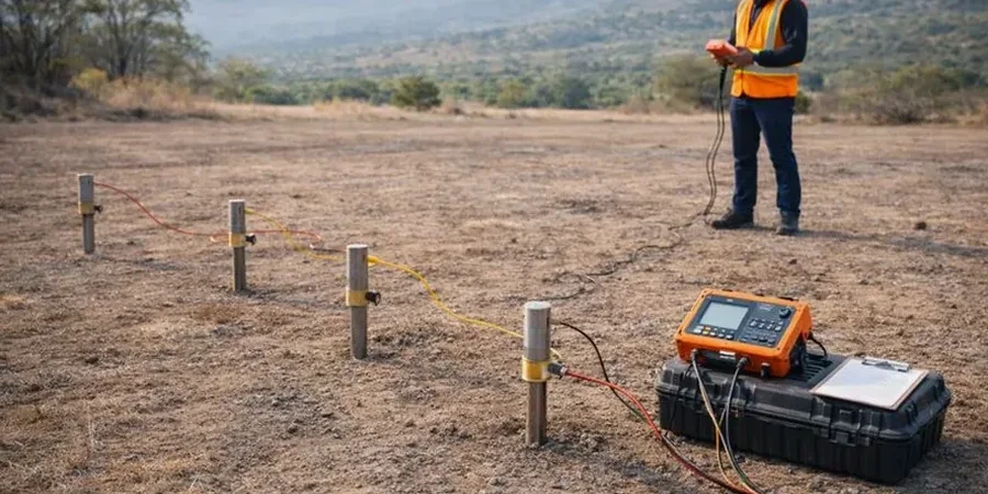
1D Vertical Electrical Sounding (VES)
Schlumberger array soundings for layer-by-layer resistivity profiles, ideal for mapping bedrock depth, water table, and clay thickness beneath a single point. Used extensively in Dallas for foundation risk assessment on lots underlain by Eagle Ford Shale.
2D Electrical Resistivity Tomography (ERT)
Multi-electrode profiles along linear transects for imaging lateral changes in subsurface resistivity. Applied along proposed pipeline routes, levee alignments, and cut slopes where continuous cross-sections reveal paleochannels and fault zones.
Soil-Resistivity Lab Correlation
We measure electrical resistivity on undisturbed Shelby tube samples at varying moisture contents and pore fluid salinities in our Dallas lab, building site-specific calibration curves that convert field resistivity values to engineering soil parameters for geotechnical reports.
Typical parameters
Quick answers
What does a VES survey in Dallas typically cost for a single-family lot?
For a standard residential lot in Dallas, a single VES sounding with data processing and a report including interpreted layer depths ranges from US$700 to US$1,070, depending on access conditions and the target investigation depth.
How deep can electrical resistivity surveys investigate in the Dallas area?
With a Schlumberger array, we routinely reach 25 to 30 meters depth by expanding current electrode spacing (AB/2) up to 100 meters. The practical limit depends on site access and the resistivity contrast of the target layers, but for most Dallas projects investigating the contact between alluvium and bedrock, 30 meters is sufficient.
Can resistivity surveys distinguish between saturated clay and clean sand in the Trinity River floodplain?
Yes, with site-specific calibration. Saturated clay typically reads below 20 Ω·m while clean sand with fresh groundwater reads 50–200 Ω·m. We refine these ranges by correlating VES data with grain-size lab results from a nearby boring, which removes ambiguity in areas where clay and sand layers interbed.
How long does a field resistivity survey take on a typical Dallas commercial site?
A single VES sounding with Schlumberger array takes about 45 to 90 minutes. A 2D ERT line of 200 meters with 4-meter electrode spacing takes roughly 2 to 3 hours for setup, data acquisition, and demobilization. Larger grids are completed in one to two field days depending on terrain and cable layout.
What surface conditions in Dallas affect resistivity data quality?
Dry surface soils, asphalt pavement, and buried utilities are the main challenges. In Dallas summers, the upper 30 centimeters of clay can be dessicated and highly resistive, so we wet electrode holes with saline solution to improve coupling. We also run a utility clearance before any survey in urban areas like Downtown or Uptown.